Tracking Hurricane 'Hilary'

Wanted to make this post for all those effected in California and storm watchers.
As the first official hurricane this year in the US, it looks like we have a couple members here that may be effected by the storm. Ski Ski Flyspud Flyspud S shadow and is there anyone else in Southern California?

Our family will keep you guys in our prayers this weekend, and will be posted updates here for those that are interested in storm tracking. Stay safe out there fellas.

Current update is showing the largest concern for Los Angeles, San Diego areas is extreme rain fall. Infrastructure in that region is not setup to support this amount of rain from what I have read.
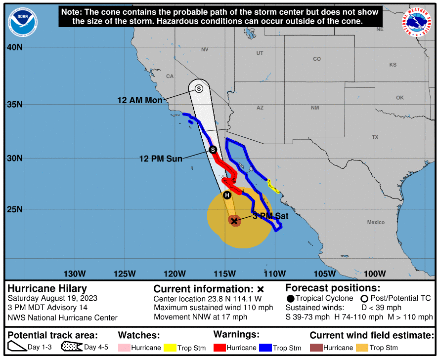
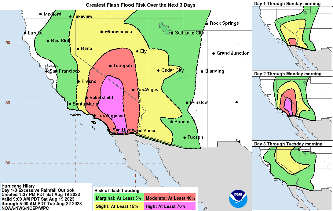
1692479986544.png


1692480104621.gif
 
Storm Summary Number 1 for Heavy Rainfall and High Wind Associated
with Tropical Storm Hilary
NWS Weather Prediction Center College Park MD
800 AM PDT Sun Aug 20 2023

1692562181153.png


...Widespread heavy rainfall and strong winds to occur over
Southern California and Nevada today as Tropical Storm Hilary
rapidly approaches from the south...

Tropical Storm Warnings are in effect over Southern California
(including the San Diego and Los Angeles metropolitan areas).

Flood Watches extend across Southern California northward, into
the Great Basin and interior Northwest.

High Wind Warnings extend across portions of the Mojave and
Sonoran Deserts northward into the Great Basin.

For a detailed graphical depiction of the latest watches, warnings
and advisories, please see www.weather.gov

At 700 AM PDT...Latest surface observations and regional radar
mosiac depict widespread moderate to heavy rainfall across much of
Southern California northward into the Great Basin. The expansive
shield of rainfall is occuring ahead of Tropical Storm Hilary,
analyzed by the National Hurricane Center with a position of
29.7N, 115.9W. Note: rainfall observations for California and
Arizona were collected beginning this Friday at 7 AM PDT, while
observations over Nevada were collected starting Saturday at 7 AM
PDT.

...Selected preliminary Storm Total Rainfall in inches from 700 AM
PDT Fri Aug 18 through 700 AM PDT Sun Aug 20...

...ARIZONA...
YELLOW JOHN MOUNTAIN 1.33
MUSIC MOUNTAIN 1.15
PARKER 1.11

...CALIFORNIA...
MT SAN JACINTO 2.53
KRN02QD 1.76
OX RANCH 1.22
OCOTILLO WELLS 1.11

...NEVADA...
LEE CANYON SNOTEL 3.10
KYLE CANYON 2.01
ASH MEADOWS 2.00


Tropical Storm Hilary is forecast to make landfall over northern
Baja later today before lifting into Southern California. Tropical
storm conditions are expected to begin later today in portions of
the Southwestern U.S. within the Tropical Storm Warning Area. For
more information regarding the track of Hilary, refer to the
National Hurricane Center at nhc.noaa.gov. Potentially historic
rainfall is expected to cause flash, urban, and arroyo flooding
across the Southwestern U.S. Dangerous to locally catastrophic
flooding impacts are expected through Monday morning. For more
information regarding the excessive rainfall assosciated with
Tropical Storm Hilary, please visit wpc.ncep.noaa.gov.

The next Storm Summary will be issued by the Weather Prediction
Center at 800 PM PDT. Please refer to your local National Weather
Service office for additional information on this event.


1692562374302.png
 
I Spoke with Ski moments ago, all is well in his area! Thankfully the storm lost a lot of strength as is approached land. Ski said it was a bad storm and rained a lot, but nothing like the potential it had.
 
I Spoke with Ski moments ago, all is well in his area! Thankfully the storm lost a lot of strength as is approached land. Ski said it was a bad storm and rained a lot, but nothing like the potential it had.
Thanks for the update!!! So good to hear!!! 🙏
 
Top